6
min read
The Documentation Infrastructure Cities Need to Win Grants
Most cities lose grants because their documentation isn't ready. See how AI-powered municipal surveys help cities win FEMA, CDBG, and state grant funding.

Katherine Zobre

Most cities know grant funding exists to address blight, aging infrastructure, and storm damage. What stops them from accessing it is almost never the need; it's the documentation. But visibility does not mean easy to access or implement. Grants, especially federal and state grants, require extensive documentation. No vague descriptions, but structured, defensible data that federal agencies, foundations, and state programs will actually accept.
Get an in-depth look at which metrics matter and how to calculate them in our blog, Community Development Metrics.
The challenge is that most counties and municipalities are trying to compile that documentation with the same shorthanded teams, complaint-driven workflows, and manual inspection processes that have always defined code enforcement. As explored in Your Team Didn't Get Bigger. It Got Smarter, the staffing crisis in local government is real and accelerating, and it's not getting better faster than the next grant deadline arrives.
The PASS AI® platform changes this not by replacing city staff's judgment, but by producing the kind of systematic, timestamped, citywide documentation that makes grant applications credible and competitive at a scale no manual process can match. City Detect’s PASS AI® is a computer vision platform purpose-built for municipal documentation, using cameras mounted on existing fleet vehicles rather than the large language models driving most AI tools. The platform operates within The Good AI™ framework. The Good AI™ framework is a standard for trustworthy, verifiable AI, built on computer vision rather than large language models, designed to produce traceable, auditable outputs with no hallucinations and no estimates, and engineered to meet the privacy and accountability standards that public institutions require.
Why Cities Lose Grants They Should Win
When cities lose grant funding (or never secure it in the first place), documentation is almost always part of the story.
Whether it's FEMA's BRIC program, HUD's CDBG Entitlement funds, or dozens of state-level equivalents, the requirement is the same: demonstrate the extent of the problem with data. Not anecdotes. Not estimates. Geotagged, timestamped, quantified data backed by photographs provides the strongest evidence.
That data requirement is a feature, not a bureaucratic obstacle. It exists because agencies need to allocate limited dollars to communities where the need is real and verifiable. But for counties and municipalities without a systematic documentation infrastructure, it can be an insurmountable wall. The need is real. The data to prove it just isn't there.
The counties and municipalities that consistently win grants are the ones that can present a complete, structured picture of conditions on the ground. They have parcel-level records, photographic evidence, comparison data showing changes over time, and documentation trails that withstand audit requirements without scrambling.
Most cities have tools to manage the grant process. What they lack is the documentation infrastructure to make applications competitive — the parcel-level data, photographic evidence, and timestamped condition records that reviewers actually need. And too often, cities try to build that documentation in the weeks before a deadline, after a disaster, or mid-recovery, which is exactly the wrong time.
What "Documentation-Ready" Actually Means
Grant reviewers aren't just looking for a narrative. They're looking for evidence that a city understands the full scope of its problem and has the systems to track remediation.
Documentation-ready data, in a grant context, typically means:
Geographic completeness. The survey covers the entire affected area, not just blocks where complaints were filed or inspectors happened to drive by. A grant application that can only document conditions on 40% of affected parcels leaves a credibility gap that reviewers notice.
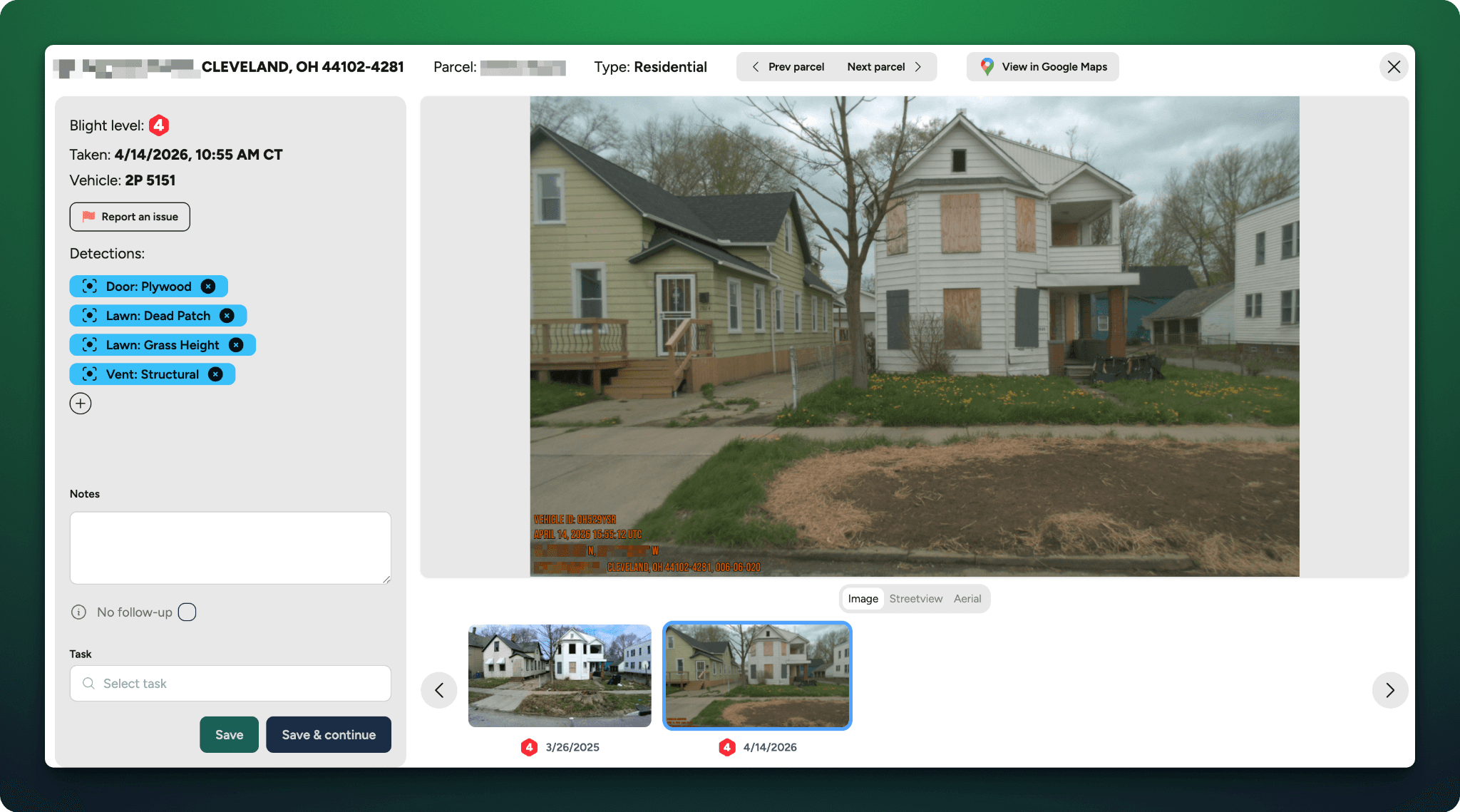
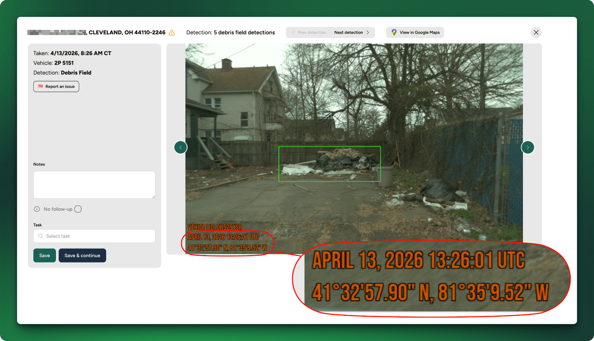
Photographic evidence tied to specific locations. Images must be geotagged and traceable to specific properties. A stack of unorganized field photos doesn't meet the standard. An AI-analyzed image library, organized by parcel and flagged by condition severity, does.
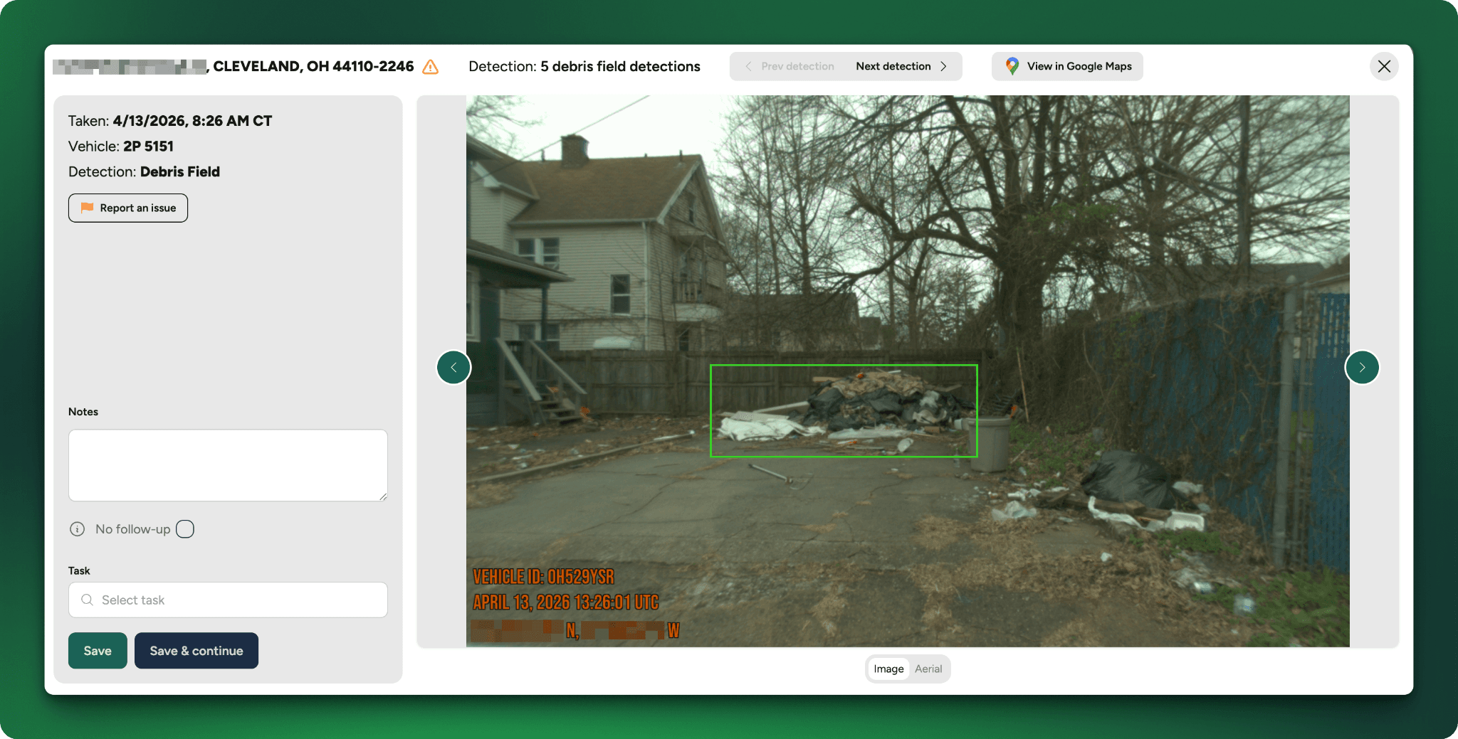
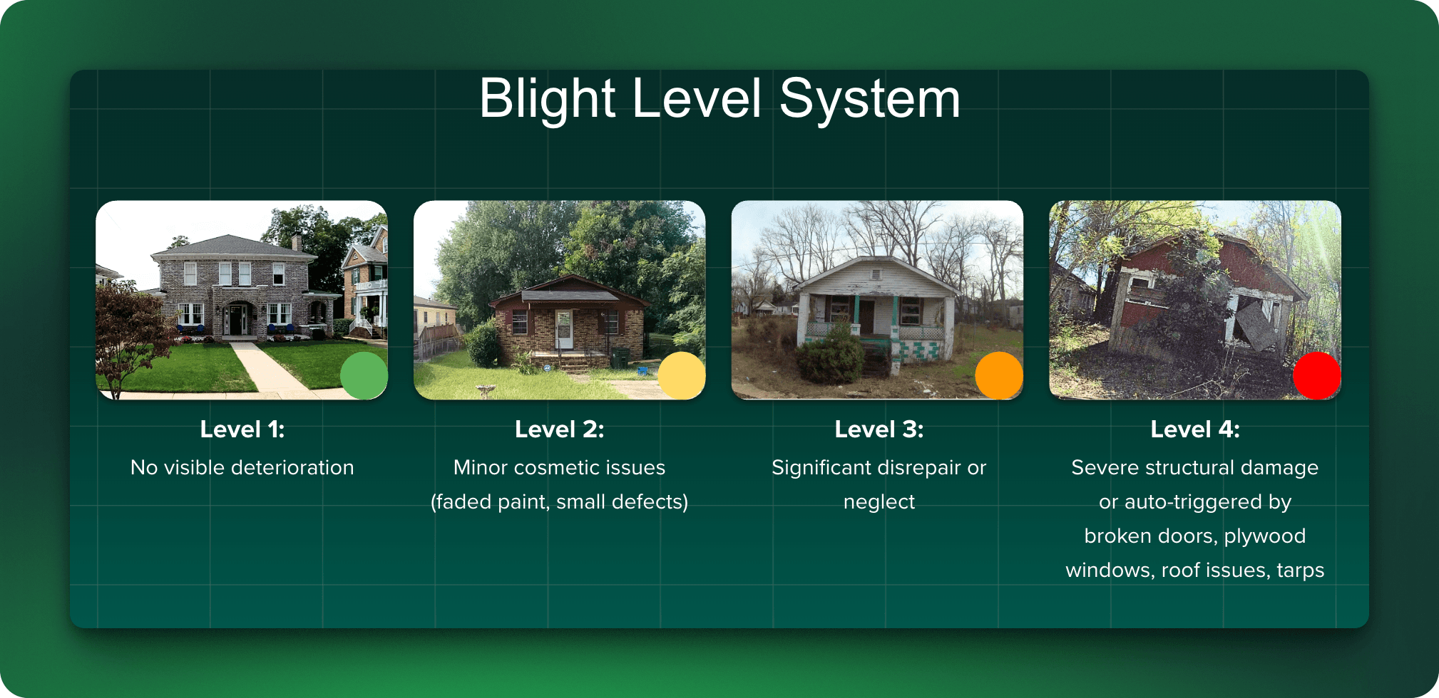
Consistent condition classification. Grant programs use standardized damage and blight classifications, substantial damage thresholds, blight indicators, code violation categories. Documentation needs to map to those standards, not to whatever terminology an individual inspector used in their notes.
Timestamps that establish baseline and progression. Documentation that captures conditions before and after an event is far more valuable than a snapshot taken mid-recovery. Cities that maintain ongoing survey data have a before-and-after picture built in.
Audit-ready record trails. Federal reimbursement programs involve audits. Documentation that can be queried, exported, and traced back to source data survives those audits. Documentation stored in spreadsheets and email threads often doesn't.
PASS AI® produces all of this as a byproduct of routine operation, not as a grant-season sprint, because it's built on The Good AI™ framework, where every data point is verifiable, and every output is traceable.
What Grant Funding Is Actually Available & What It Requires
The scale of available funding for cities that can document need compellingly is significant — and it extends well beyond the federal programs most departments have on their radar.
At the federal level, FEMA's Building Resilient Infrastructure and Communities (BRIC) program explicitly includes virtual inspection technology as an eligible activity, and CDBG entitlement funds remain one of the most flexible instruments available for blight remediation, housing code enforcement, and vacant lot inventories. But federal funding is just one lane on a much wider road.
States are increasingly stepping up with their own housing mandates and dedicated grant programs that require municipalities to document conditions, identify problem properties, and track progress against reporting mandates. Philanthropic funders focused on housing stability and neighborhood revitalization are also actively funding municipal partnerships — and they're competitive opportunities for departments that can speak the language those funders care about: data, outcomes, and equity.
State-level programs vary widely, but the requirement structure mirrors the federal one: show us the problem, show us the scope, show us the plan. Cities that have already been producing systematic documentation don't have to build the application from scratch — they're pulling from data they already have.
How PASS AI® Builds a Grant-Ready Documentation Record
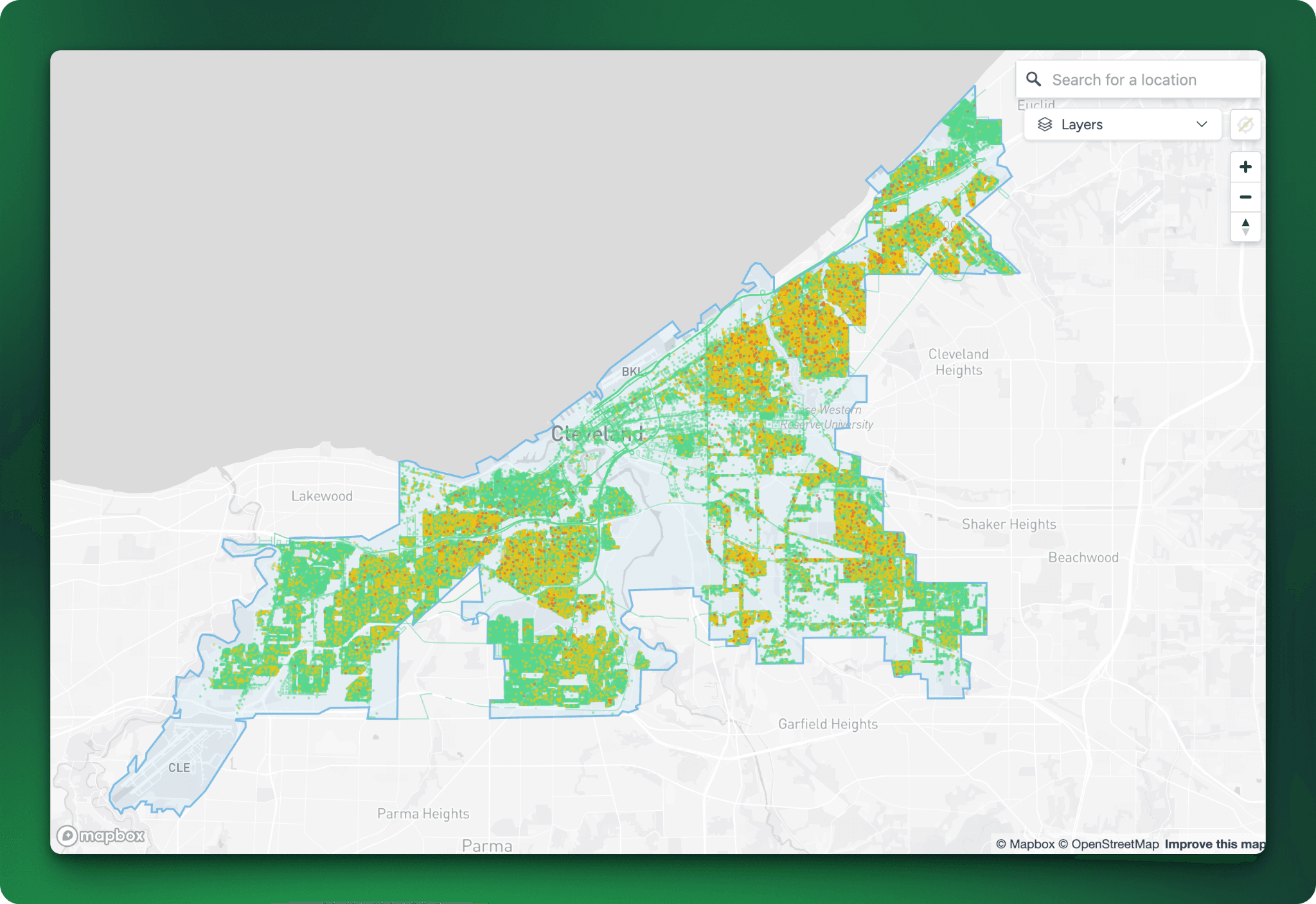
Every fleet route becomes an intelligence-gathering pass. Every image gets analyzed by computer vision trained to identify blight indicators, structural deterioration, storm damage, and code violations.
The result isn't just a list of problems. It's a structured, timestamped, parcel-indexed record of conditions across the entire city, organized in a format that maps directly to the documentation requirements of major grant programs.
For post-storm grant applications specifically, this matters enormously. As covered in After the Storm: The Real Work, the FEMA reimbursement clock starts ticking immediately, and cities that can't produce comprehensive property-level documentation within the application window leave money on the table permanently. Cities that have pre-storm baseline data through ongoing AI surveys can demonstrate damage progression — exactly what FEMA auditors need to see.
In Greenville, South Carolina, following Hurricane Helene, City Detect surveyed 300 miles of storm-affected roadway and surfaced approximately 1,200 high-severity damage indicators. That data supported Greenville's compliance with FEMA audit requirements and helped unlock federal recovery funding. The systematic documentation wasn't built for the grant, it was built for the city. The grant application benefited because the data was already there.
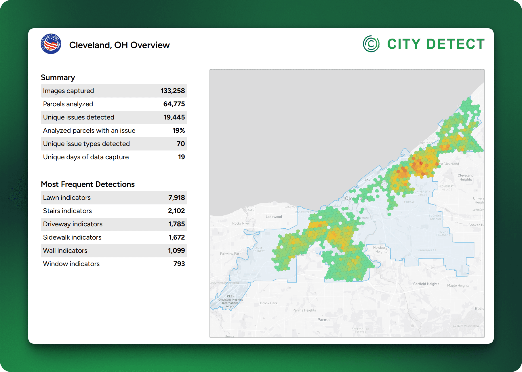
In Stockton, California, the system captured nearly 200,000 images across close to 40,000 parcels, surfacing 13,852 unique issues. That coverage gives Stockton the kind of baseline data that makes blight remediation grant applications competitive, not just claims of a widespread problem, but a documented inventory of it.
Documentation as Ongoing Infrastructure, Not Emergency Response
The deeper shift that PASS AI® enables isn't a one-time documentation project. It's a shift in how counties and municipalities view data as a permanent municipal asset.
Counties and municipalities with ongoing AI-powered surveys accumulate something that no single grant-season effort can replicate: a longitudinal record of conditions over time. That record makes every subsequent grant application stronger. It makes progress reporting more credible. It makes audit compliance faster. And it creates the kind of institutional documentation capacity that surveyors, planners, and code enforcement directors have wanted for decades but couldn't staff for.
Code enforcement teams working with City Detect don't just get a snapshot. They get a living dataset that updates with every fleet pass, giving administrators a continuously current picture of conditions across every neighborhood — the ones where people call in complaints and the ones where they don't.
That equity dimension matters for grant applications too. Federal programs increasingly require grantees to demonstrate that funded activities reach historically underserved communities. Documentation that shows AI-powered surveys covering every neighborhood directly supports that requirement.
How Cities Reclaim Time on Grant Applications and Compliance Reporting
Grant funding is competitive. Two cities can apply to the same program with the same level of genuine need and walk away with very different outcomes. Those who invest in documentation infrastructure, before the disaster, before the application deadline, before the audit, are consistently turning a need into resources.
PASS AI® isn't a grant-writing tool. It's the platform that makes grant writing substantive. And because it operates under The Good AI™ framework, the data is trustworthy. No guessing, no hallucinating. So, when reviewers ask for property-level data, it's there. When auditors ask for photographic evidence, it's geotagged and organized. When program officers ask about coverage of low-income neighborhoods, the answer is documented, not estimated.
Cities that invest in documentation infrastructure before the deadline, before the disaster, before the audit are the ones that consistently convert genuine need into federal and state grant funding.
Your city's needs are real. The question is whether your documentation is ready to prove it.
Frequently Asked Questions
What documentation does FEMA require for BRIC grant applications and reporting?
BRIC subrecipients face rigorous documentation requirements throughout the entire Period of Performance. Quarterly Performance Progress Reports must document project status and scope of work completion, while Federal Financial Reports track spending and cost-share status. For projects in the National Competition, Go/No-Go milestone tracking is required — missed milestones can result in cancellation of the subaward.
Photographic and visual documentation is explicitly required under two governing policy documents: the Hazard Mitigation Assistance Program and Policy Guide (Version 2.1, 2025) and the Public Assistance Program and Policy Guide (Version 5.0, 2025). FEMA may require multiple photographs of property exteriors and interiors to certify scope of work completion, and GPS-tagged photographs are required to document location-specific threats and site conditions. For Capability- and Capacity-Building activities — the category that covers virtual inspection technology — documentation must demonstrate a tangible output such as an inventory map or digital enforcement log.
Cities that maintain ongoing AI-powered surveys through PASS AI® enter the reporting cycle with that documentation already structured, timestamped, and parcel-indexed — rather than scrambling to compile it after the fact. Read more in FEMA’s Hazard Mitigation Assistance Program and Policy Guide version 2.1 from 2025.
What documentation does HUD require for CDBG-funded code enforcement activities?
CDBG funds can cover code enforcement salaries, overhead, and legal proceedings under 24 CFR 570.202(c), but only within designated target areas — typically neighborhoods that are at least 51% Low-to-Moderate Income (LMI) and documented as deteriorated or deteriorating. Enforcement must also be paired with companion improvements like street repairs or rehabilitation loans to demonstrate a strategy to arrest neighborhood decline.
Documentation requirements are rigorous. If audited, HUD will ask for a map showing the specific boundaries of the target area, census or survey data confirming LMI status, inspector timesheets showing hours worked exclusively within that area, and case files for each violation that include photographic evidence, notices sent to property owners, and resolution records.
While federal regulations don't mandate a photo of every violation, photographic evidence is effectively required for two reasons:
1) to justify the area's eligibility through a blight or deterioration study, and
2) to support before-and-after documentation for any federally funded repair or legal proceeding.
Cities using PASS AI® enter this process with geotagged, timestamped, parcel-level imagery already organized by location — satisfying the area boundary, case file, and photographic documentation requirements that HUD auditors expect to see, without requiring staff to reconstruct evidence after the fact.
What is the difference between competitive grants and formula allocations like CDBG? Competitive grants like FEMA's BRIC program award funding based on the strength of the application. Formula allocations like HUD's CDBG Entitlement funds are distributed based on population and need metrics — but both require the same underlying documentation: parcel-level data, photographic evidence, and compliance reporting that withstands federal audit requirements.
How does AI-powered municipal documentation save cities time on grant applications? Cities using AI-powered survey and mapping platforms like PASS AI® build documentation continuously as fleet vehicles conduct routine routes. When a grant deadline arrives, the data is already structured, timestamped, and parcel-indexed, eliminating the scramble to compile evidence from scratch and significantly reducing staff time on both applications and compliance reporting.
Ready to see how City Detect helps municipalities build grant-ready documentation infrastructure? Contact our team today →
Related Reading
After the Storm: The Real Work — Why comprehensive documentation is the deciding factor between a swift recovery and a decade-long struggle.
Your Team Didn't Get Bigger. It Got Smarter. — How AI gives shorthanded code enforcement teams citywide visibility that no complaint queue ever could.
Choosing The Good AI™: A Privacy-First Framework for Cities — The questions city leaders should be asking before adopting any AI tool.


